NSV(Network Survey Vehicle)
NSV (Network Survey Vehicle) survey using Leica ‘Pegasus Two’ NSV / LiDAR system with pavement camera, for all 2/4/6/8 lane Highways in India, as per MORTH policy guidelines on NSV survey issued vide letter No. RW / NH-33044/ 32/2019-S&R (P&B), dated 13th November, 2019.
Ministry of Road Transport & Highways vide letter No. RW / NH-33044/ 32/2019-S&R (P&B), dated 13th November, 2019 has created policy guidelines on surveying with Network Survey Vehicle (NSV) in India. According to this policy, it is decided that for all the projects in India involving development of 2/4/6/8-lane, Expressway, stage strengthening, necessarily be surveyed with NSV before start of the construction work, after completion of the work, and thereafter at regular intervals (every 6 months after completion of the work) for each lane of the pavement.
As per the policy guidelines, the minimum parameter which has to be recorded during survey with NSV in each lane are as following, but not limited to :
- Inventory of Road: GPS coordinates, Pavement Type, Pavement Width, Terrain, Land use, Shoulder type and width, Drain Type and Width, Median Type and Width, Wayside Amenities, Crash barrier, Signage’s etc. (Note- All inventory items shall be recorded both side of road and Geo-tagged with images / 360 degrees panoramic views).
- Condition of Road: Roughness, Rutting, Distresses (Cracking, Potholes, Bleeding, Surface failure etc.); (Note- All inventory items shall be recorded for each lane and Geo-tagged).
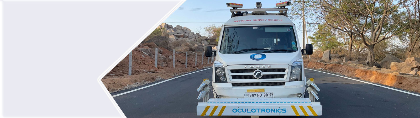
‘ARC Testing Lab’ has more than 15 years of experience in the field of professional Land Surveying, Mapping & GIS, using the modern & innovative technologies. Accordingly, we have acquired NSV(Network Survey Vehicle) of Leica ‘Pegasus Two’ along with the pavement camera in March 2015 for survey of the highways in India. We have carried out the survey of more than 11,000 Km of Expressways, National Highways, State Highways & Major District Roads in the past few years with our Two numbers of Leica NSV / LiDAR instruments owned by us.

We have all necessary resources and equipment in-house, like two numbers of “Leica Pegasus Two” NSV / Mobile LiDAR Instruments with pavement cameras, Leica GS14 DGPS RTK receivers, high capacity Work Stations, licensed software’s, skilled manpower, with sufficient experience, for Survey of Inventory of Road & Condition of Road as per MORTH policy requirements, with high quality and accuracy within optimum cost & given time frame.
We at ‘Prashant Surveys’ have the capacity to undertake the NSV survey works of any type of 2/4/6/8 lane Highways in India. Presently we can capture about 200 Lane Km length of highways per day, using our two numbers of ‘Leica Pegasus Two’ NSV systems.
The deliveries include the International Roughness Index (IRI), surface distress like potholes, cracks (crack index), rutting, bleeding shown in the vector form in *.dwg file by using the automatic ‘Road Assessment Tools’ of Leica Map Factory software.
Key points of NSV Survey using our NSV 'Leica Pegasus Two with pavement camera’
- NSV data of the pavement has to be collected for each lane with the speed of vehicle varying from 10 Km / hour up to 70 Km / hour. Ideal vehicle speed maintained by us is usually 40 to 50 Km / hour on Highways during each lane of NSV data capture.
- Each run of NSV with pavement camera can capture about 3.5 m width of the highway lane with dense 3D point cloud data, 360 degrees panoramic view camera data with high density pavement camera and GNSS / IMU data. Multiple runs are usually required for capturing more than one lanes on Highways and Expressways as per the project requirements.
- In one day, about 100 lane Km length of NSV data can be easily collected by 'Leica Pegasus Two' NSV with pavement camera in a single run.
- The raw NSV data collected on site is so dense (about 100 GB data collected for 100 lane Km length of highway) that it has to be downloaded into external hard disk and transported to the head office for further data processing and pavement analysis.
- LiDAR data processing and registration on 3D point cloud is done using 'Leica Auto Process' software, whereas the feature extraction of point, line and polygon features are done using multiple licenses of Leica Map factory software. Final delivery of ‘Road Inventory’ dwg is made in Arc GIS shape files or Autocad *.dwg files as per the requirements of the client. Whereas the delivery of ‘Pavement Condition’ survey is made in Autocad *.dwg files and MS Excel format along with georeferenced photographs collected by the pavement camera.